
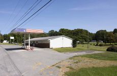
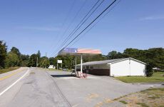




Martin's Store 4830 Highland Trail, Alderson, WV 24910
Commercial store on 1 acre of land- Owner Financing possibilities
Marketing description
Martin’s Store at Fort Spring and rentals located between Alderson and Ronceverte on Route. 63. Excellent location; the property has approx. 1.16 acres with a large multi-purpose commercial building. Has most recently operated as a convenience store with gas and a restaurant. This is the opportunity to own your own business; the sky is the limit with this great property. This property is not in the floodplain but is located near the Greenbrier River.
ATTRIBUTES AND HIGHLIGHTS
- Possible Owner Financing for qualified buyers
- Great small business opportunity
- Convenience store, restaurant, sporting goods, deli, and many other possibilities
- Near the busy Greenbrier River Campground
- A busy highway for Lewisburg, Ronceverte, and Alderson connection
- Near the Greenbrier River
- Many possibilities for numerous types of businesses
- (2) ten-thousand-gallon tanks
- The tank monitoring system is in place
- Walk-in cooler
- Large deli
- A ready to go dining area
- A busy highway with excellent visibility
- Well and septic system
- Paved front and parking
- Close to the busy Greenbrier River Campground
- The Greenbrier River attracts many for fishing, kayaking, canoeing, tubing, and relaxing.
- The closest convenience store is 5 miles from Alderson and 8 miles from Ronceverte or Fairle.a
- FedEx and UPS delivery location
- Convenient location to Camp Cupcake FPC at Alderson
LOCATION
Google Coordinates: 37°44’42.6″N 80°33’48.7″W
Address: 4830 Highland Trail, Alderson, WV, 24910
Elevation: 1638 ft. +/-
UTILITIES
Water: Well
Sewer: Septic
Electricity: Mon Power
Telephone: Frontier, Countrymen,
Internet: Frontier, Countrymen, Starlink
ACCESS/FRONTAGE
The property fronts Route 63
ZONING
Greenbrier County is subject to some zoning and subdivision regulations. All prospective buyers should consult the County Commission and the Health Department for details regarding zoning, building codes, and installation of septic systems.
Information can be found at the county website: http://greenbriercounty.net/ordinances/.
DEED and TAX INFORMATION
Greenbrier County, West Virginia
Deed Information: DB 533 Page 251
Acreage: From calculations, approx. 1.15 Acres – ACREAGE .70(D)FROM ALLEN LOT 8 COLONIAL ACRES S/D RT 63 RONCEVERTE 281X193X404X100 and ACREAGE .46(D)FROM BOOTH LOT 9 COLONIAL ACRES S/D RT 63 RONC 120X231X112X281
Real Estate Tax ID/Acreage/Taxes:
Greenbrier County (13), West Virginia
Fort Springs (6)
Tax Map 18A Parcels 8 and 9
2025 Real Estate Taxes: $469.00
PUBLIC SCHOOLS
Greenbrier County School District
Public Elementary School:
Alderson Elementary School
Public Middle School:
Eastern Greenbrier Middle School
Public High School:
Greenbrier East High School
SURROUNDING AREA
FORT SPRING
Fort Spring is an unincorporated community and coal town in Greenbrier County, West Virginia, USA. It is situated along the Greenbrier River within the Greenbrier River Watershed. It was once a substantial portion of the Chesapeake and Ohio Railway by way of the Gravel Gertie route from Hinton in Summers County, West Virginia, to Clifton Forge in Virginia. The name originates from its primary export: Mississippian limestone from Snowflake Quarry, which was sent to Clifton Forge, Virginia. The main road running through the small town was once the original rail line, but it has since been relocated.
Fort Spring was originally called “Mann’s Ferry,” and the community’s current name refers to the old settler fort that has been lost to history. The rock cliff, or bluff, seen just before the primary two train tunnels when traveling eastward, was named ‘Wilson’s Bluff’ because a family settled there. Colonel John Stuart, who shipped Ice Age sloth bones (Megalonyx jeffersonii) to Thomas Jefferson, noted the presence of saltpeter caves in the area. The area is characterized by a combination of karst topography, riparian floodplains, and ancient riverbeds with limestone (karst) outcroppings, interspersed with farmlands and deciduous forests. The only available drinking water is from drilled wells, cisterns, or transportation.
Thanks to recent West Virginia tourism promotions, Fort Spring has become a popular spot for launching kayaks and other types of boats on day trips to the nearby town of Alderson.
ALDERSON
The Town of Alderson, affectionately known as the “Gem of the Hills,” is tucked away in the lush Greenbrier Valley of southern West Virginia. It is situated along the beautiful Greenbrier River and includes both Greenbrier and Monroe Counties.
In 1763, the nearby Muddy Creek settlements were destroyed by Shawnee Indians under Chief Cornstalk. It was not until 1777 that the town was settled by “Elder” John Alderson, a frontier missionary for whom the town was named. It was here that he founded the first Baptist church in the Greenbrier Valley and later established a Baptist seminary, which was later relocated north to become Alderson-Broaddus College in Philippi, WV.
The Federal Reformatory for Women, the first federal prison for women, was established here in 1927. The town is renowned for its annual Independence Day festival, which West Virginia Living Magazine acknowledged as the state’s “Best Independence Day Celebration” in 2012.
Alderson, WV, today is primarily a residential community with retail establishments in its downtown historic district. These serve the numerous camps and vacation homes along the Greenbrier River, as well as tourists visiting the surrounding countryside. Commerce and property values are increasing due to increased tourism and the sheer beauty of the river and surrounding farms. Alderson contains many fine homes from the turn of the 20th Century, many of which are in mint condition, never altered from their well-tended, original appearance.
The town of Alderson has been an active community for generations. The largest and most popular 4th of July parade in the state is hosted by the Town of Alderson. Alderson’s amenities include churches, elementary schools, motels, banks, Dollar General, Family Dollar, gas and convenience stores, medical clinics, a pharmacy, and restaurants. Alderson is situated along the Greenbrier River in Greenbrier County and Monroe County, and was incorporated in 1881. Alderson was originally settled in 1777 by “Elder” John Alderson, a frontier missionary for whom the town is named. Alderson is also home to “Camp Cupcake,” the minimum-security federal prison where Martha Stewart spent her vacation.
Lewisburg, the Greenbrier County seat, was voted the Coolest Small Town in America and is just a 20-minute drive from the thriving downtown historic district. The downtown area boasts a year-round live theatre, Carnegie Hall, a new $ 3 million library, several fabulous restaurants, antique shops, and boutiques. There is also a modern hospital, all attendant medical facilities, and numerous big-box stores. Several new schools have been built in the area.
The Greenbrier County Airport, which has West Virginia’s longest runway, is located just 25 minutes away and offers daily flights to Chicago and Washington, D.C. The world-famous Greenbrier Resort is a 25-minute drive, and Snowshoe Ski Resort is about a 2-hour drive. Blacksburg, Virginia (Vtech) is about 90 minutes away, Roanoke, Virginia, is 120 minutes away, DC is 4 hours away, and Charlotte, North Carolina, is 3.5 hours away.
Just 30 minutes from Sandstone Falls, Bluestone Lake, Bluestone State Park, and Pipestem Resort, the surrounding area offers an abundance of recreational activities, including white-water rafting, golfing, fishing, camping, hiking, bird-watching, and rock climbing. Snow skiing at the Winterplace Resort is less than an hour away. In 10 minutes, you can catch the Amtrak train in Alderson and ride to the Greenbrier Resort, Chicago, or New York City. The Beckley Airport is just 45 minutes away. The new 10,000-acre Boy Scout high adventure camp is an hour’s drive, and the 14,000-acre Wildlife Management Area is just across the river at Bull Falls.
WATER RESOURCES
THE GREENBRIER RIVER
The lower Greenbrier River possesses the excitement of life on one of the nation’s great wild rivers. The focus of a vast outdoor recreation destination flows untamed out of the high Alleghenies, attracting anglers, paddlers, and naturalists from across the globe.
At 162 miles long, the Greenbrier is the longest undammed river left in the Eastern United States. It is primarily used for recreational pursuits and is well known for its fishing, canoeing, kayaking, and floating opportunities. Its upper reaches flow through the Monongahela National Forest, and it is paralleled for 77 miles by the Greenbrier River Trail, a rail trail that runs between the communities of Cass and North Caldwell.
It has always been a valuable water route, with many of the important cities in the watershed establishing themselves as river ports. The river gives the receiving waters of the New River an estimated 30% of its water volume. Over three-fourths of the watershed is an extensive karstic (cavern system) supporting fine trout fishing, cave exploration, and recreation. Many important festivals and public events are held along the river throughout the watershed.
The Greenbrier is formed at Durbin in northern Pocahontas County by the confluence of the East Fork Greenbrier River and the West Fork Greenbrier River, both of which are ephemeral streams rising at elevations exceeding 3,300 feet and flowing for their entire lengths in northern Pocahontas County. From Durbin, the Greenbrier flows generally south-southwest through Pocahontas, Greenbrier, and Summers Counties, past several communities, including Cass, Marlinton, Hillsboro, Ronceverte, Fort Spring, Alderson, and Hinton, where it flows into the New River.
Along most of its course, the Greenbrier accommodated the celebrated Indian warpath, the Seneca Trail (Great Indian Warpath). From the vicinity of present-day White Sulphur Springs, the Trail followed Anthony’s Creek down to the Greenbrier near the present Pocahontas-Greenbrier County line. It then ascended the River to the vicinity of Hillsboro and Droop Mountain. It made its way through present Pocahontas County by way of future Marlinton, Indian Draft Run, and Edray.
THE NEW RIVER AND BLUESTONE LAKE
Nearby, in about a 25-minute drive to the New River and 2000-acre Bluestone Lake at Hinton. The New River is the second-oldest in the world, preceded only by the Nile; it is the oldest river in North America. The New River is unique because it originates in Blowing Rock, North Carolina, and flows north through Virginia into West Virginia. The Nile and Amazon are the only other major rivers that also flow north. It produces more citation fish yearly than any other warm water river in WV. Smallmouth bass, largemouth bass, crappie, catfish, sunfish, hybrid striped bass, and muskie are all common species of fish found in the New River and Bluestone Lake.
Bluestone Lake is over 2000 acres at the summer pool and is the state’s third-largest body of water. Excellent hunting and fishing opportunities abound at the 17,632-acre Bluestone Wildlife Area adjacent to the park and nearby Camp Creek State Forest.
Lewisburg, the Greenbrier County seat, was voted the Coolest Small Town in America and is just a 35-minute drive from the thriving downtown historic district. The downtown boasts a year-round live theatre, Carnegie Hall, a new $3MM library, several fabulous restaurants, antique shops, and boutiques. There is also a modern hospital, all attendant medical facilities, and all the big box stores. Several new schools have been built in the area.
DIRECTIONS
Located on Route 63, approximately. 1.5 miles from the intersection of Fort Spring Turnpike. Approx. 4.5 miles from the Alderson intersection of Rt. 12 & 63.
Investment highlights
- Partial Owner Financing Possibities May Exist
- Excellent ingress and egress to Route 63 Highland Trail
Listing Contacts
Valuation Calculator
Valuation Metrics
Map
Broker Selected Comps View More Comps
Property History

Similar Properties
Additional Information
Is there information that looks off?
