


Listed by Atlanta Land Group
$24,310,000
22 McDaniel Station
Details
Property Type Land
Sub Type Commercial, Industrial
Acreage 286.000
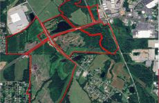
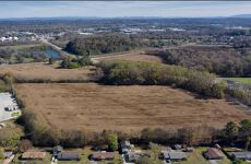
Land | 286 acres
Marketing description
+/-286 Acres
First major intersection West of retail Calhoun. Prime real estate for commercial, residential, and/or industrial use.
Hwy 53 & McDaniel Station Road
Land Use Plan: Mixed Use
Current Zoning: Agricultural
Gordon County
All Utilities
Signalized Intersection
All 4 Pin Corners
0.75 Miles to Big Box Retail
2.2 Miles to I-75
1.4 Miles to Hwy 41
2 Miles to Downtown Calhoun
Investment highlights
+/-286 Acres
First major intersection West of retail Calhoun. Prime real estate for commercial, residential, and/or industrial use.
Hwy 53 & McDaniel Station Road
Land Use Plan: Mixed Use
Current Zoning: Agricultural
Gordon County
All Utilities
Signalized Intersection
All 4 Pin Corners
0.75 Miles to Big Box Retail
2.2 Miles to I-75
1.4 Miles to Hwy 41
2 Miles to Downtown Calhoun
Listing Contacts
Listed by Atlanta Land Group
Valuation Calculator
Login or Sign up to see Valuation Metrics
Sign up for Crexi to see valuation metrics for this property
Loan Amount
$0.00
Annual Debt Service
$--
$--
Annual Cash Flow
$--
$--
Valuation Metrics
0
DSCR
--
Cap Rate
--
ROI
Map
Zoning
UK SpecialUnknown
View municipality zoning documents Upgrade to see the zone description and what's allowed on this property
Upgrade to search and view land use codes
Last updated Jan 15, 2026 For deeper zoning details, reports are available at Zoneomics
Broker Selected Comps View More Comps
Property History
Similar Properties
Additional Information
Name
License
Brokerage
Title
Is there information that looks off?