


4950 Benton Road
Land | 17.18
Marketing description
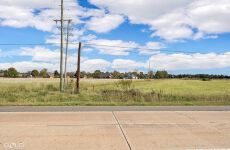
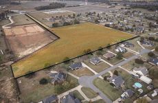
Positioned along the highly traveled Benton Road corridor in North Bossier, this exceptional 17.18-acre tract presents a rare opportunity to secure prime development land in one of the fastest-growing areas in the Shreveport-Bossier market. Located just north of Vanceville Road at the terminus of Britton Road, the property offers both visibility and accessibility while maintaining the privacy and flexibility developers and investors seek. The site features generally level terrain with natural drainage and open pastureland, providing a strong foundation for future development. Public utilities including city water, community sewer, electricity, natural gas, and telecommunications are available in the surrounding area, supporting a wide range of potential uses. The tract benefits from direct access to Benton Road via an approximately 86-foot-wide access corridor, allowing efficient entry into the main body of the property while maintaining excellent frontage exposure. Zoned R-A (Residence Agricultural District), the property is ideally suited for rural residential or subdivision development, with zoning that supports estate-style lots and residential expansion consistent with the area's growth patterns. Surrounding land uses include established residential neighborhoods, expanding subdivisions, community facilities, and additional vacant development tracts, reinforcing the long-term demand for housing and supporting services in this corridor. The property is strategically positioned within a rapidly expanding residential market north of Interstate 220, an area that has experienced significant population growth and increased commercial and retail expansion designed to serve nearby communities. The site provides convenient access to major transportation arteries including Benton Road, Airline Drive, Swan Lake Road, and Interstate 220, allowing seamless connectivity to Bossier City, Shreveport, Barksdale Air Force Base, healthcare facilities, retail centers, and major employment hubs. Flood mapping indicates that the majority of the property lies within Zone X, outside special flood hazard areas, with only a small portion located within Zone A, offering additional flexibility for site planning and development design. Whether envisioned as a residential subdivision, estate-style development, or long-term investment hold, this tract offers scale, location, and development potential rarely found in today’s market.
Listing Contacts
Valuation Calculator
Valuation Metrics
Map
Broker Selected Comps View More Comps
Property History
Similar Properties
Additional Information
Is there information that looks off?