


80 ACRES LAND WITH MOUNTAIN, RESERVOIR, & DESERT VIEWS
Land | 79.92 acres
Marketing description
79.92 acres raw land. Very close to the Lower Pitt-Taylor Reservoir and the Rye Patch Reservoir beyond that, which means great water views, plus frequent views of birds and other wildlife. A pleasant place for camping and off-road recreation, and/or potentially for your home, family, animals, landscape, views, and quietude, right here on these 80 acres. Close proximity to area employers such as the Florida Canyon mine and the planned West Coast Salmon facility. Rural, yet easy to get to. Expansive and tranquil views of mountains, reservoirs, and desert in all directions. Only 1.75 miles driving to Interstate 80. This could be just the right property for you.
Zoned AMR (agriculture, mining, recreation), which allows a wide variety of potential uses including building a home.
Located about 3,000 feet northwest of the Union Pacific railroad line and 4,000 feet northwest of Interstate 80, with easy access to both the Humboldt House freeway interchange to the west and the Imlay interchange to the east. A very lightly traveled, faint dirt road reaches the property and continues to/through its northern boundary, ending just north of the property. Services are available nearby both west and east of the property along Interstate 80, primarily at the Rye Patch interchange and the Imlay/Mill City interchanges. Humboldt House/Imlay is located about 20 minutes west of Winnemucca, 2 hours east of Reno, and 4 hours west of Salt Lake City, all lying along Interstate 80.
This is an off-grid location. Solar or wind appear to be the best methods of generating electricity, or alternatively electric lines are located about 4500 feet away. Water is typically obtained via private well and sewage disposal via private septic tank. Propane delivery service is available locally.
Property to be sold as-is, where-is. Buyer to conduct their own due diligence with regards to development possibilities, utilities, etc to ensure property meets Buyer's needs.
Pershing County APN 008-180-12
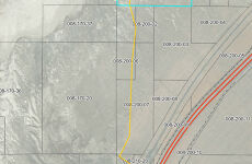
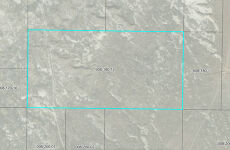
Directions: Take Interstate 80 east from Reno. Exit at Humboldt House, which is exit 138. Upon exiting, go to the northwest side of the freeway, and turn right onto the frontage road. Reset your odometer and go 0.3 miles, then turn left. Proceed straight for 0.3 additional miles, crossing the railroad tracks and passing a house on your left, then turn right onto the unnamed dirt road. Go straight (northeast) 0.2 miles, bearing left at the first fork you come to. Reset your odometer again, and proceed straight (north) on this road for 1.1 miles, at which point the road will cross the southern boundary of the property. There is a for sale sign on the property near the point where this road crosses onto the property. From here the property continues roughly 430 feet to the west, 2200 feet to the east, and 1300 feet to the north. All four property corners are marked with 10' tall white PVC pipes flying blue survey tape at the top (be advised grazing cattle sometimes knock these markers down, which makes them more difficult to find). See attached images and maps to assist you in identifying the property. There is no official street address yet for the property, so please type the GPS coordinates into Google Maps to locate the property; an official street address will be assigned by the County at the time of building.
GPS 40.61691, -118.25473 (south portion of property at road)
What3Words ///coincidence.warm.checklists
Investment highlights
79.92 acres raw land. Very close to the Lower Pitt-Taylor Reservoir and the Rye Patch Reservoir beyond that, which means great water views, plus frequent views of birds and other wildlife. A pleasant place for camping and off-road recreation, and/or potentially for your home, family, animals, landscape, views, and quietude, right here on these 80 acres. Close proximity to area employers such as the Florida Canyon mine and the planned West Coast Salmon facility. Rural, yet easy to get to. Expansive and tranquil views of mountains, reservoirs, and desert in all directions. Only 1.75 miles driving to Interstate 80. This could be just the right property for you.
Zoned AMR (agriculture, mining, recreation), which allows a wide variety of potential uses including building a home.
Located about 3,000 feet northwest of the Union Pacific railroad line and 4,000 feet northwest of Interstate 80, with easy access to both the Humboldt House freeway interchange to the west and the Imlay interchange to the east. A very lightly traveled, faint dirt road reaches the property and continues to/through its northern boundary, ending just north of the property. Services are available nearby both west and east of the property along Interstate 80, primarily at the Rye Patch interchange and the Imlay/Mill City interchanges. Humboldt House/Imlay is located about 20 minutes west of Winnemucca, 2 hours east of Reno, and 4 hours west of Salt Lake City, all lying along Interstate 80.
This is an off-grid location. Solar or wind appear to be the best methods of generating electricity, or alternatively electric lines are located about 4500 feet away. Water is typically obtained via private well and sewage disposal via private septic tank. Propane delivery service is available locally.
Property to be sold as-is, where-is. Buyer to conduct their own due diligence with regards to development possibilities, utilities, etc to ensure property meets Buyer's needs.
Pershing County APN 008-180-12
Directions: Take Interstate 80 east from Reno. Exit at Humboldt House, which is exit 138. Upon exiting, go to the northwest side of the freeway, and turn right onto the frontage road. Reset your odometer and go 0.3 miles, then turn left. Proceed straight for 0.3 additional miles, crossing the railroad tracks and passing a house on your left, then turn right onto the unnamed dirt road. Go straight (northeast) 0.2 miles, bearing left at the first fork you come to. Reset your odometer again, and proceed straight (north) on this road for 1.1 miles, at which point the road will cross the southern boundary of the property. There is a for sale sign on the property near the point where this road crosses onto the property. From here the property continues roughly 430 feet to the west, 2200 feet to the east, and 1300 feet to the north. All four property corners are marked with 10' tall white PVC pipes flying blue survey tape at the top (be advised grazing cattle sometimes knock these markers down, which makes them more difficult to find). See attached images and maps to assist you in identifying the property. There is no official street address yet for the property, so please type the GPS coordinates into Google Maps to locate the property; an official street address will be assigned by the County at the time of building.
GPS 40.61691, -118.25473 (south portion of property at road)
What3Words ///coincidence.warm.checklists
Listing Contacts
Valuation Calculator
Valuation Metrics
Map
Zoning
Broker Selected Comps View More Comps
Property History
Similar Properties
Is there information that looks off?