


ELE_CO_ForbesPark01
2.22 Acres Mountain View Land in Forbes Park, Costilla, CO
Marketing description
Land Description:
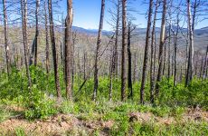
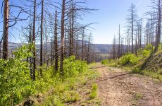
This 2.22-acres land is in Forbes Park a covenant-protected community nestled in the Sangre de Cristo Mountains of Costilla County, Colorado. Developed by Forbes, Inc. since 1977, it comprises 3,346 lots spanning from 1 to 14 acres, totaling approximately 13,046 acres. Situated between Walsenburg and Alamosa, just west of La Veta Pass and on the east side of the San Luis Valley, Forbes Park offers easy access via Hwy. 160. Refer to the provided map for precise directions.
The terrain of Forbes Park slopes southwestward, with elevations ranging from 8,500 to 10,500 feet. Bordered by Wagon Creek to the north, Trinchera Ranches to the west, and National Forests to the south and east, the area is densely wooded, with internal drainage flowing mainly west and northward.
Climate and Environment:
Forbes Park enjoys a moderated climate due to its elevation, with winter highs averaging in the mid-20s to mid-30s Fahrenheit and summer highs typically in the mid-70s, rarely exceeding 80°F. Annual snowfall averages around 200 inches, complemented by approximately 10 inches of rainfall. The landscape comprises subalpine forests, sagebrush, and meadows.
Flora and Fauna:
Diverse tree species such as aspen, limber pine, spruces, firs, ponderosa pines, and bristlecone pines populate Forbes Park, with forests covering 55% of the area. Wildlife abounds, including deer, elk, coyotes, bobcats, mountain lions, black bears, prairie dogs, wild turkeys, blue grouse, various birds of prey, porcupines, and trout in the onsite creeks, among others.
Investment highlights
This 2.22-acre plot lies within Forbes Park, a protected community nestled in Colorado’s Sangre de Cristo Mountains. Established by Forbes, Inc. in 1977, it encompasses 3,346 lots spread across 1 to 14 acres, totaling around 13,046 acres. Conveniently located between Walsenburg and Alamosa, near La Veta Pass, and accessed via Hwy. 160, Forbes Park is easily reachable. Bounded by Wagon Creek to the north, Trinchera Ranches to the west, and National Forests to the south and east, it boasts dense woodlands and westward/northward drainage. See the map for precise directions.
Listing Contacts
Valuation Calculator
Valuation Metrics
Map
Broker Selected Comps View More Comps
Property History
Similar Properties
Is there information that looks off?