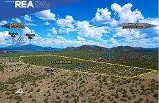


Espee Rd Estate ±161.22 Net Acres
Residential Land | 161.22 Acres
Marketing description
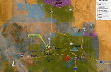
LOCATION: The property is approximately 10 miles north of Williams in Red Lake, Coconino County, Arizona. Espee Road, a dedicated county road, is paved asphalt and generally the northern property boundary. About two miles to the east is Highway 64, which provides access to the Grand Canyon to the north and Interstate 40 to the south. Buck Ridge Road bisects the Property and provides access to Junipine Estates subdivision immediately south of the property.
ACCESS: Assess to the Property is provided by Espee Rd and connects to Highway 64 to the east.
PROPERTY: The property is 161.22 Net Acres in size (168.83 gross acres), consisting of gently rolling topography at an elevation of 6,500’ to 6,600’. It has expansive views toward the Grand Canyon. The property is heavily treed with beautiful large pinyon and juniper trees throughout. Arizona State Trust lands border the property to the east, west, and part of the southern boundary. The Junipine Estates subdivision borders to the south. The entire property is fenced with barb wire.
CLIMATE: The neighborhood typically has a beautiful four-season climate. Weather records from Williams (6,800’) show, on average, 21” of rain and 70” of snow. Average high/low temperatures in July are 83.6°F /53.3°F. Average high/low temperatures in January are 45.1°F /19.6°F.
WILDLIFE: It is in the AZG&F Unit 10 with huntable wildlife species noted in this unit as: Pronghorn Antelope, Bighorn Sheep, Black Bear, Elk, Javelina, Merriam's Turkey, Mountain Lion, Mule Deer, White-tailed Deer.
COMMENTS: The property is well suited for development, with paved road access and electricity/telephone utilities to the Property. It borders the higher-density Junipine Estates subdivision, which has one-acre-sized lots. The land is attractive with large, treed vegetation and views to the north toward the Grand Canyon.
Investment highlights
Zoning: G-General, 10-Acre Minimum Lot Size
Flood Zone: Flood Maps (Flood Insurance Rate Map #04005C6330G) Do Not Show Any Mapped Flood Hazards On The Property.
Electricity To The Property (Arizona Public Service) – Buyer To Verify
Telephone To The Property (CenturyLink Or Other) – Buyer To Verify
Water (to be by Cistern/Hauling)
Sewer (to be by Septic)
Other (Propane, Trash And Tv/Internet Are From Private Providers)
Listing Contacts
Valuation Calculator
Valuation Metrics
Map
Zoning
Broker Selected Comps View More Comps
Property History
Tax History
Similar Properties
Additional Information
Is there information that looks off?