


631 Acres of Heaven And 10 Acres of Mineral Rights
631 Acres in Wikieup, AZ
Marketing description
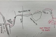
Cross Streets: US 93 and Lower Trout Creek Rd Directions: SEE DRIVING MAP in PHOTOS: Just north of town, Take Lower Trout Creek Road East from US 93. It turns in to Trout Creek Rd. Stay on it until you reach any of the GPS Coordinates listed below. Signs up soon
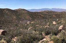
Public Remarks: Three Parcels adding up to 631 Acres of beautiful mountains, valleys, flat land....everything you would ever want in a secluded ranch away from it all but only minutes from the town of Wikieup and about one hour from Kingman! Plenty of State and Federal Trust land all around so bring your toys! Seller says depth for drilling a well is only about 250 feet! Trout Creek Road runs through all three parcels. See map pictures in the photos. GPS Coordinates: 252-01-019: Latitude 34.8971242038619 Longitude -113.485372525131........252-01-020: Latitude 34.8934551623909 Longitude -113.485327012347........252-01-018: Latitude 34.9025463222907 Longitude -113.485282666322
Listing Contacts
Valuation Calculator
Valuation Metrics
Map
Broker Selected Comps View More Comps
Property History
Similar Properties
Is there information that looks off?