


Listed by The Whitney land company
$300,000
Blue Mtn Foothill CRP Homesite
Details
Property Type Land
Sub Type Farm
Acreage 73.300
Blue Mtn Foothill CRP Homesite Price: $300,000 Overview: Located just beyond the city limits of
Marketing description
Blue Mtn Foothill CRP Homesite
Price: $300,000
Overview:
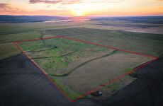
Located just beyond the city limits of Pendleton, Oregon, at the base of the scenic Blue Mountain foothills, the Blue Mtn Foothill CRP Homesite offers 73.30± acres of flat and gently rolling native grassland. Once used as productive farmland, the property is now enrolled in the Conservation Reserve Program (CRP), providing annual returns to the landowner. Elevated portions of the acreage showcase expansive western views overlooking the scenic McKay Valley making it an ideal spot to build a home.. Positioned within the boundaries of the Confederated Tribes of the Umatilla Indian Reservation, this property combines income potential with a peaceful rural setting.
Explore the opportunity to own land that offers both long-term value and a unique connection to Eastern Oregon’s natural beauty.
Homesite:
The property’s AG2 (Farm/Pasture) zoning under CTUIR’s land development code allows for a singlefamily dwelling with accessory uses, including manufactured homes, and Accessory Dwelling Units (ADUs) per Section 3.445(1–4). This means a buyer may have the opportunity to build both a primary residence and an ADU—such as a guest house, rental unit, or caretaker’s quarters—subject to approval through the CTUIR Planning Department. Permitting is required and processed by the Tribal Planning Office, which reviews zoning classification and issues development permits. A buyer should plan for coordination with CTUIR early in the process to confirm design and site requirements, but the existing AG2 designation positions the property well structure residential development.
It should be noted- A portion of the property is enrolled in the Conservation Reserve Program (CRP). Buyers interested in building will need to work with the Natural Resources Conservation Service (NRCS) to remove the intended homesite from the CRP contract. Buyers are responsible for all due diligence related to eligibility, process, and any associated penalties, and agree to hold Seller harmless from any claims, costs, or obligations arising from the removal or development process.
Planning/Building:
The Tribal Planning Office will generally be your first stop if you want to build on the property. The current Planning & Building staff will help ensure sure all projects on the Umatilla Indian Reservation have the necessary permits, and they review all proposed projects for adherence to the CTUIR Land Development Code and all the adopted Building Codes. Once permits are issued, Planning & Building staff also provides inspection services for ongoing work on constructed, renovated, or demolished buildings. Buyer to do own Due Diligence with the Tribal Planning Department to ensure Buyer's satisfaction of the buildable aspect of the property. 541-276-3099 -Tribal Planning Department
Buyer(s) should review the Sub-Chapter AG-2 zoning description of the Land Development Code for the Confederated Tribes of the Umatilla Indian Reservation and Development Permit Process as part of their Due Diligence for building on the property.
Acreage Breakdown:
Total County Deeded Acres: 73.30±
Tillable / CRP Acres: ± (FSA Reported) Tract-76.21
CRP Acres: ± 75.99
Leases:
Currently-USDA-CRP Contract. No other known leases.
United States Department of Agriculture – Farm Service Agency:
Farm – 4920
Tract – 2719
Crop Ground:
According to the FSA mapping, the property has a total of 76.21 +/- tillable production acres. Of the 75.99 acres, currently,75.99+/- acres are enrolled in Conservation Reserve Program (CRP) through 9/30/2030. The annual rental rate per acre for 75.99+/- acres is $57.00 The annual contract payment is $4,331.00+/-. Payment:100%-Cliff Hoeft
Map & Tax Lot:
1S33-00-05100 Account Numbers: 102641
Jurisdiction: CTUIR-Confederated Tribes of the Umatilla Indian Reservation
County:
Umatilla County, OR
Zoned: AG-2
2024 Taxes: $334.94
Near By Towns:
Pilot Rock, OR- 10 +/- Miles
Pendleton, OR- 14 +/- Miles
Hermiston, OR- 41 +/- Miles
Tri-Cities, WA- 81 +/- Miles
Portland, OR- 220 +/- Miles
Boise, ID- 224 +/- Miles
Access:
Access to the property is from Motanic Road, a County maintained gravel road approximately 14 miles South East of Pendleton, OR.
Local Area Utilities:
Electrical-Umatilla Electric Co-op or Pacific Power
Propane- Morrow County Grain Growers
Garbage- Tribal Waste Management
Cell service LTE is located at the home site.
Wi-Fi: W-Tech link provides 4 Mbps or 8 Mbps plans in that area. Current monthly rates are $39 +/- per month for 4 Mbps and $63 +/- for 8 Mbps. Buyer to do own Due Diligence as to a service charge for bringing Wi-Fi to the home site. (If any).
Water:
There is no domestic water source established on the property. However, neighboring wells in the area have been drilled to depths of approximately 300 feet, with water typically encountered around 173 feet.
Pasture/Topography:
The property has approximately ten acres on the bottom that is flat ground. The remaining acreage is primarily gently slopped native CRP vegetation that aids as a cover crop for soil health, erosion control and wildlife.
Boundary lines/Fencing:
The property boundary is not fenced; Buyers are to do their Due Diligence to their own satisfaction with boundary lines.
Surrounding bordering land:
The property is bordered to the North by CTUIR Farmground. The Remaining borders are believed to be private landowners.
Wildlife:
The property owners have seen a variety of wildlife on the property, including deer, elk, upland game birds.
Confederated Tribes of the Umatilla Indian Reservation
The Umatilla reservation, Nicht-Yow-Way Country, is the home of the Cayuse, Umatilla and Walla Walla Bands of Native American Indians. When the leaders of the three tribes signed a treaty with the United States in 1855, they ceded 6.4 million acres of homeland in what is now northeastern Oregon and southeastern Washington. The 172,000-acre Umatilla Indian Reservation, almost half of which is owned by non-Indians, includes significant portions of the Umatilla River watershed.
Today the confederation, united under a single tribal government adopted in 1949, numbers over 2,800 members (2011). The Umatilla are governed by a Board of Trustees composed of nine members elected by the General Council. Tribal headquarters are located in Mission, just outside Pendleton, Oregon.
The Umatilla River and Grande Ronde rivers have been the focus of the tribe’s fish restoration activities for more than a decade. Under the tribe’s leadership, salmon were reintroduced in the Umatilla River in the early 1980s. The tribe, along with the state of Oregon, operates egg-taking, spawning, and other propagation facilities that are helping restore salmon runs. The tribe successfully reintroduced chinook salmon to the Umatilla River after 70 years of extinction.
Other river basins in which the tribe has co-management responsibilities are the Columbia, Snake, Walla Walla, Tucannon, Grande Ronde, John Day, and Imnaha. In recent times, tribal fisheries have occurred only on the Umatilla and Columbia rivers.
Umatilla County:
Umatilla County was created on September 27, 1862, out of a portion of Wasco County. Umatilla is an Indian term meaning "rippling water" or "water rippling over sand" and has provided the name both for the county and its major river. Lewis and Clark and pioneers traveling the Oregon Trail passed through the area. The gold rush of 1862 brought miners and stock raisers to the mountains and grasslands of Umatilla County. The county expanded after the coming of the railroad in 1881 and the area was open to the development of dry land wheat farming. The fertile land of Umatilla County gives a strongly agricultural base to the county's economy. Fruit, grain, timber, cattle, and sheep are important agricultural products. Recreation, primarily in the Blue Mountains, and tourism, most notably for the annual Pendleton Round-Up rodeo, are also important to the local economy.
Resources:
Listing Contacts
Listed by The Whitney land company
Valuation Calculator
Login or Sign up to see Valuation Metrics
Sign up for Crexi to see valuation metrics for this property
Loan Amount
$0.00
Annual Debt Service
$--
$--
Annual Cash Flow
$--
$--
Valuation Metrics
0
DSCR
--
Cap Rate
--
ROI
Map
Broker Selected Comps View More Comps
Property History
Tax History
Similar Properties
Additional Information
Name
License
Brokerage
Title
Is there information that looks off?