


40 ACRES OPEN COUNTRY LAND
40 ACRES OPEN COUNTRY LAND
Marketing description
40 ACRES OPEN COUNTRY LAND
40.06+- acres raw land. Near the town of Imlay and the neighborhood of Mill City. A pleasant place for camping and off-road recreation, and/or potentially for your home, family, animals, landscape, views, and quietude. With close proximity to area employers such as the Florida Canyon mine, the planned West Coast Salmon facility, and local businesses, this could prove the perfect location for settling into. Rural, yet easy to get to. Expansive and tranquil views of mountains and desert in all directions. The nearest Interstate 80 interchange is within a 5+- minute drive.
Zoned AMR (agriculture, mining, recreation), which allows a wide variety of potential uses including building a home, subject to applicable permitting requirements.
Located south of Interstate 80, with easy access to both the Imlay freeway interchange to the west and the Mill City interchange to the east. Three very lightly traveled dirt roads pass by the area and the property from both the east and the west. Services are available nearby both east and west of the property along Interstate 80, primarily at the Imlay and Mill City interchanges. The property is located about 20 minutes west of Winnemucca, 2 hours east of Reno, and 4 hours west of Salt Lake City, all lying along Interstate 80.
This is an off-grid location. Solar or wind appear to be the best methods of generating electricity, or alternatively electric lines are located to both the north and the east of the property within less than a mile. Water is typically obtained via private well and sewage disposal via private septic tank. Propane delivery service is available locally.
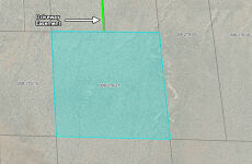
East Star Peak Road is a dirt road recently resurfaced by the County. The land comes with a deeded driveway easement across the adjacent property to the north.
One or more adjacent parcels may be available if you desire additional acreage; please inquire.
Property to be sold as-is, where-is. Buyer to conduct their own due diligence with regards to development possibilities, utilities, etc to ensure property meets Buyer's needs.
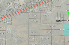
Pershing County APN 008-270-21
GPS 40.65420, -118.11535
What3Words ///searches.planting.crucial
Directions: The following directions are one possible route toward the property along existing dirt roads. This area of the desert has many existing dirt roads; other routes may be more or less feasible. Take Interstate 80 east from Reno. Exit at Imlay, which is exit 145. Upon exiting, go to the south side of the freeway, and turn left onto the frontage road. The road will turn from asphalt to gravel, and pass the Thunder Mountain Monument park. At the east end of the park, the road will fork. Take the left side of the fork. Continue another 500 feet, at which point the road will fork again. This time take the right side of the fork--this is E Star Peak Rd. Reset your odometer at this point and go straight for 0.7 miles, at which point the property will be on your right. All four property corners are marked with 10' tall white PVC pipes flying blue survey tape at the top (be advised grazing cattle sometimes knock these markers down, which makes them more difficult to find). See attached images and maps to assist you in identifying the property. There is no official street address yet for the property, so please type the GPS coordinates into Google Maps to locate the property; an official street address will be assigned by the County at the time of building.
Investment highlights
40 ACRES OPEN COUNTRY LAND
40.06+- acres raw land. Near the town of Imlay and the neighborhood of Mill City. A pleasant place for camping and off-road recreation, and/or potentially for your home, family, animals, landscape, views, and quietude. With close proximity to area employers such as the Florida Canyon mine, the planned West Coast Salmon facility, and local businesses, this could prove the perfect location for settling into. Rural, yet easy to get to. Expansive and tranquil views of mountains and desert in all directions. The nearest Interstate 80 interchange is within a 5+- minute drive.
Zoned AMR (agriculture, mining, recreation), which allows a wide variety of potential uses including building a home, subject to applicable permitting requirements.
Located south of Interstate 80, with easy access to both the Imlay freeway interchange to the west and the Mill City interchange to the east. Three very lightly traveled dirt roads pass by the area and the property from both the east and the west. Services are available nearby both east and west of the property along Interstate 80, primarily at the Imlay and Mill City interchanges. The property is located about 20 minutes west of Winnemucca, 2 hours east of Reno, and 4 hours west of Salt Lake City, all lying along Interstate 80.
This is an off-grid location. Solar or wind appear to be the best methods of generating electricity, or alternatively electric lines are located to both the north and the east of the property within less than a mile. Water is typically obtained via private well and sewage disposal via private septic tank. Propane delivery service is available locally.
East Star Peak Road is a dirt road recently resurfaced by the County. The land comes with a deeded driveway easement across the adjacent property to the north.
One or more adjacent parcels may be available if you desire additional acreage; please inquire.
Property to be sold as-is, where-is. Buyer to conduct their own due diligence with regards to development possibilities, utilities, etc to ensure property meets Buyer's needs.
Pershing County APN 008-270-21
GPS 40.65420, -118.11535
What3Words ///searches.planting.crucial
Directions: The following directions are one possible route toward the property along existing dirt roads. This area of the desert has many existing dirt roads; other routes may be more or less feasible. Take Interstate 80 east from Reno. Exit at Imlay, which is exit 145. Upon exiting, go to the south side of the freeway, and turn left onto the frontage road. The road will turn from asphalt to gravel, and pass the Thunder Mountain Monument park. At the east end of the park, the road will fork. Take the left side of the fork. Continue another 500 feet, at which point the road will fork again. This time take the right side of the fork--this is E Star Peak Rd. Reset your odometer at this point and go straight for 0.7 miles, at which point the property will be on your right. All four property corners are marked with 10' tall white PVC pipes flying blue survey tape at the top (be advised grazing cattle sometimes knock these markers down, which makes them more difficult to find). See attached images and maps to assist you in identifying the property. There is no official street address yet for the property, so please type the GPS coordinates into Google Maps to locate the property; an official street address will be assigned by the County at the time of building.
Listing Contacts
Valuation Calculator
Valuation Metrics
Map
Zoning
Broker Selected Comps View More Comps
Property History
Similar Properties
Is there information that looks off?