


Listed by Houlihan Lawrence
$250,000
Rt-301
Details
Property Type Land
Acreage 20.440
Land | 20.44 acres
Marketing description
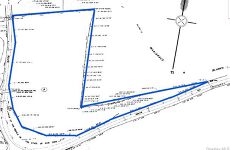
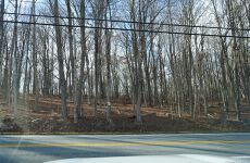
Gently sloping 20+ acre parcel of wooded land fronting Route 301 just across from Farmer's Mill Rd.. State has taken small area at intersection of Farmer's Mill in a curve straightening project. Otherwise, this parcel follows the west side of Route 301 from the Union Halstead graveyard through the curve and west beyond the Farmer's Mill intersection.
Listing Contacts
Listed by Houlihan Lawrence
Valuation Calculator
Login or Sign up to see Valuation Metrics
Sign up for Crexi to see valuation metrics for this property
Loan Amount
$0.00
Annual Debt Service
$--
$--
Annual Cash Flow
$--
$--
Valuation Metrics
0
DSCR
--
Cap Rate
--
ROI
Map
Zoning
C CommercialGeneral CommercialCommercial
View municipality zoning documents Upgrade to see the zone description and what's allowed on this property
Upgrade to search and view land use codes
View all 42 uses
View all 42 uses Last updated Mar 5, 2026 For deeper zoning details, reports are available at Zoneomics
Broker Selected Comps View More Comps
Property History
Similar Properties
Is there information that looks off?