


Unpriced
72.45 Acres Ampad Road
Details
APN 55R-42 ; ID: 56R-96; 56R-97 ;6R-98
Property Type Land
Sub Type Commercial, Industrial
Price Per Acre $35,000
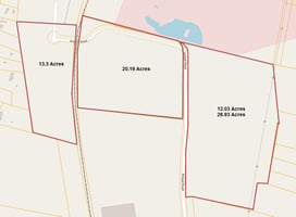
Acreage 12.03 - 38.96
Zoning Industrial
Land
Marketing description
For Sale
Investment highlights
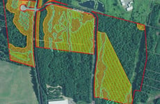
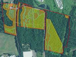
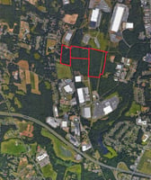
- Location: off service star industrial way and Ampad northside industrial park off route 10/202, contiguous to summit lock industrial park.
- Zoning/coverage: industrial 50%
- Totgraphy ranges: level
- Terrain: grassy, low brush
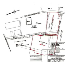
- Wetlands: please see the attached
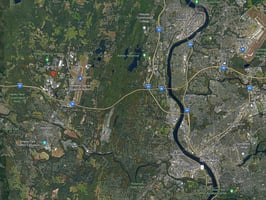
- Distance: 1 ½ miles to exit 41 mass pike, 7 miles to i-91
- Water: city of westfield 8” main in Ampad road to Ampad driveway
- Sewer: city of westfield 8” main in Ampad road to farthest north point
- Gas: Westfield gas & electric 4 steel 90 psi line in Ampad road up to Ampad building, 4” high pressure plastic planned to serve the remainder of the sites
- Electric: Westfield gas & electric 23 KVA, 3 phase overhead on Ampad road
- 13.3 Acres $35,000/Acre
- Parcel ID: 55R-42 (western parcel)
- Wetland Area: 3.0 acres
- Upland: 12.4 acres
- 22.15 Acres $35,000/Acres
- Parcel ID: 56R-96 (middle parcel)
- Wetland Area: 9.8 acres
- Upland: 12.8 acres
- 38.96 Acres $35,000/Acre
- Parcel ID: 56R-97 12.03 acres (eastern parcel)
- Parcel ID: 56R-98 26.93 (eastern parcel)
- Wetland Area: 12.2 acres
- Upland: 25.1 acres
Valuation Calculator
Login or Sign up to see Valuation Metrics
Sign up for Crexi to see valuation metrics for this property
Loan Amount
$--
Annual Debt Service
$--
$--
Annual Cash Flow
$--
$--
Valuation Metrics
0
DSCR
--
Cap Rate
--
ROI
Broker Selected Comps View More Comps
Property History
Similar Properties
Additional Information
Name
License
Is there information that looks off?