


RE/MAX FREEDOM
Listed by RE/MAX FREEDOM
$4,750,000
Mariposa
Details
APN 0357581020000
Property Type Land
Sub Type Lots/Land
Acreage 123.350
Land | 123.35 acres
Marketing description
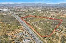
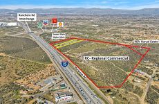
**PREMIER 123.35-ACRE REGIONAL COMMERCIAL ASSEMBLY MARIPOSA ROAD CORRIDOR BETWEEN THE OAK HILL AND RANCHERO ROAD INTERCHANGES. Contiguous 123.35-acre parcel with approximately 2,384 LF of Mariposa Road frontage forming the western boundary. Across I-15 from the Silverwood (Tapestry) Specific Plan a 15,000+ unit master planned community under active construction. **ZONING: Main Street & Freeway Corridor Specific Plan (MSFC-SP), Freeway-South District. Split designation per the Hesperia GP Land Use Map effective 8/19/2025: Regional Commercial (RC) on the dominant westerly portion, Rural Estate Residential (RER) on the southeast corner. Permitted RC uses include big-box regional retail, hotels, restaurants, entertainment, offices, and auto sales Auto Row / regional commercial planning intent. Maximum commercial FAR 0.23; maximum building height 65 ft. RC multi-family residential mixed-use is restricted to the I-15/Main Street Interchange District and does not apply to this parcel. **OVERLAYS: Wash Protection Overlay maps across the eastern portion of the parcel area. SCE high-voltage Utility Corridor traverses the northern strip. Open Space / Drainage footprint on the southeast corner. **UTILITIES: City water and sewer mains terminate at the Ranchero / I-15 interchange; service to the parcel requires main extension or Hesperia Water District annexation. SCE service available via on-parcel transmission corridor. **FLOOD & DRAINAGE: FEMA NFHL indicates Zone X for the surrounding area; panels covering this area (06071C6475H, 7180J, 7185H) are "Not Printed" final determination
Listing Contacts
RE/MAX FREEDOM
Listed by RE/MAX FREEDOM
Valuation Calculator
Login or Sign up to see Valuation Metrics
Sign up for Crexi to see valuation metrics for this property
Loan Amount
$0.00
Annual Debt Service
$--
$--
Annual Cash Flow
$--
$--
Valuation Metrics
0
DSCR
--
Cap Rate
--
ROI
Map
Zoning
OH/RL ResidentialSingle FamilyOak Hills Rural Living
View municipality zoning documents Upgrade to see the zone description and what's allowed on this property
Upgrade to search and view land use codes
View all 72 uses
View all 72 uses Last updated Mar 4, 2026 For deeper zoning details, reports are available at Zoneomics
Broker Selected Comps View More Comps
Property History
Similar Properties
Is there information that looks off?