


Listed by Aspen Properties Inc
$1,889,000
1945 S State Route 260
Details
APN 406-13-046-N
Property Type Office, Hospitality
Sub Type Commercial, Medical Office
Price per SqFt $3
Price Per Acre $114,554
Acreage 16.490
Zoning PAD Commercial
Office
Marketing description
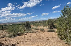
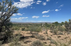
Presenting a rare opportunity to acquire approximately 16 acres of commercially zoned and PAD designated land located directly off State Route 260 in the growing market of Cottonwood, Arizona. This 5-parcel property offers exceptional visibility, access, and flexibility for a wide range of uses including retail, hospitality, medical, office, or mixed-use development. Gorgeous views of the Sedona red rocks and Mingus Mountain. Close to I-17, Sedona, Jerome, Camp Verde, and Clarkdale. The Verde Valley is home to many tourist attractions including wildlife parks, museums, national monuments, hot springs, railroads, hiking trails, fishing, and wineries.
Investment highlights
- Additional Parcels: Yes
- Adjacent To Wash
- Lot Size Acres: 16.49
- Lot Size Dimensions: Irregular
- Topography: Gentle Sloping, Level
- Vegetation: Natural Vegetation
- Lot Size Square Feet: 735728
- Fencing: Pipe, Barbed Wire
- Road Surface Type: Dirt, Asphalt
- Annual Tax Amount: 8290
- Source Listing Status: Active
- County: Yavapai
- Cross Street: State Route 260
- Development Status: Raw Land
- Directions: Take I-17 To State Route 260 Towards Cottonwood. Continue 11.3 Miles To The 5-Parcel Property On Your Right,
- Tax Year: 2025
- Distance To Electric Comments: On Property
- Distance To Sewer Comments: Within 1/2 Mile
- Source Property Type: Land
- Possible Use: Commercial, PAD
- Parcel Number: 406-13-046-N
- Postal City: Cottonwood
- Public Survey Section: 12
- Township: 15
- Zoning: PAD Commercial
Listing Contacts
Listed by Aspen Properties Inc
Valuation Calculator
Login or Sign up to see Valuation Metrics
Sign up for Crexi to see valuation metrics for this property
Loan Amount
$0.00
Annual Debt Service
$--
$--
Annual Cash Flow
$--
$--
Valuation Metrics
0
DSCR
--
Cap Rate
--
ROI
Map
Zoning
PAD PlannedPlanned Unit Development
View municipality zoning documents Upgrade to see the zone description and what's allowed on this property
Upgrade to search and view land use codes
View all 3 uses
View all 3 uses Last updated May 8, 2026 For deeper zoning details, reports are available at Zoneomics
Broker Selected Comps View More Comps
Property History
Similar Properties
Is there information that looks off?