




High-Visibility ±1.61-Acre Commercial Corner in Winder
High-Visibility ±1.61-Acre Commercial Corner in Winder
Marketing description
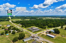
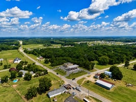
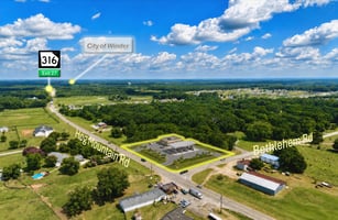
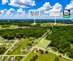
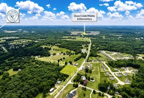
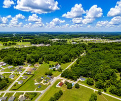
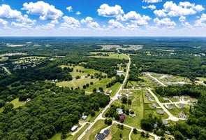
936 Bethlehem Road offers a highly visible ±1.61-acre commercial corner at the intersection of Bethlehem Road and Hog Mountain Road/Highway 53 in Winder, Georgia. With exposure along two established roadways and a prominent corner configuration, the property presents an attractive opportunity for neighborhood retail, convenience-oriented commercial, professional office, medical office, restaurant, or service-based development.
A Level III Soil Survey dated May 7, 2026, evaluated the entire 1.61-acre tract for potential on-site wastewater disposal. Nine soil borings identified Cecil and Pacolet soil series, both assigned a Suitability Code “A.” According to the report, these soils are well drained, free of significant limitations, and should be capable of accommodating conventional absorption fields when properly designed, installed, and maintained.
The soil evaluation reported no indication of hard rock or seasonal groundwater within 72 inches at the tested locations. Estimated percolation rates were approximately 50 to 60 minutes per inch, with recommended trench depths of 24 to 36 inches. These findings provide useful preliminary support for development in an area where access to an on-site wastewater system may be important.
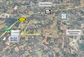
The property also benefits from convenient access to Georgia Highway 316, connecting Barrow County with the Atlanta metropolitan area, Gwinnett County, and Athens. Its dual-road visibility, surrounding residential base, soil findings, and conceptual development potential make 936 Bethlehem Road a compelling opportunity for an owner-user, developer, or commercial investor.
The soil survey is encouraging, but it does not constitute an approved septic permit or guarantee a particular commercial wastewater capacity. Final feasibility will depend on the proposed use, wastewater volume, system design, reserve-area requirements, setbacks, and approval by the Georgia Department of Public Health and local Environmental Health Department.
The survey also states that its boundary and mapped features are not survey-accurate. Additionally, the soil table lists slope ranges of 10%–20%, while the property map labels the Cecil and Pacolet areas as 0%–5%. I recommend avoiding a specific slope representation in the brochure until the soil consultant confirms that discrepancy.
Marketing Disclaimer
Property information is believed to be accurate but is not guaranteed. The Level III Soil Survey provides preliminary soil-suitability information and does not represent an approved septic permit or guarantee development capacity. All proposed uses, access points, utilities, wastewater systems, site plans, setbacks and improvements are subject to independent verification and approval by the appropriate governmental authorities. Conceptual renderings are for illustrative purposes only.
Conceptual Rendering Disclaimer
The gas-station rendering is conceptual and is provided solely to illustrate one potential development scenario. It is not an approved site plan and should not be relied upon as confirmation of zoning, access, setbacks, utility capacity, stormwater requirements, environmental conditions, or development feasibility. Buyers should independently verify all information with the appropriate governmental authorities and professional consultants.
Investment highlights
±1.61-acre commercial corner parcel
Located at Bethlehem Road and Hog Mountain Road/Highway 53
High visibility from two established roadways
Frontage along both Bethlehem Road and Hog Mountain Road
Potential for multiple access points, subject to governmental approval
Convenient access to Georgia Highway 316
Positioned to serve Winder, Bethlehem, and surrounding Barrow County communities
Surrounded by established residences and continued area growth
Suitable for a range of neighborhood-oriented commercial concepts
Conceptual convenience-store and fuel-station rendering available
Entire 1.61-acre tract evaluated by a Level III Soil Survey
Nine soil-boring locations evaluated across the property
Cecil and Pacolet soil series identified
Both soil classifications assigned Suitability Code “A”
Soils described as well drained and free of significant limitations
No hard rock encountered within 72 inches at tested locations
No seasonal groundwater encountered within 72 inches at tested locations
Estimated percolation rates of approximately 50–60 minutes per inch
Conventional absorption fields may be feasible with proper design, installation, and approval
Former house site identified on the soil plan
A bored well was identified near the Bethlehem Road side of the property
Strong potential for an owner-user, developer, or commercial investor
Listing Contacts
Valuation Calculator
Valuation Metrics
Broker Selected Comps View More Comps
Property History

Tax History
Similar Properties
Additional Information
Is there information that looks off?
