


Listed by ERA Brokers Consolidated
$481,440
Four Parcels sold separately-total 149.4 +/- Acres
Details
APN 218-20-000-003
Property Type Land
Sub Type Industrial
Broker Co-Op Yes
Acreage 80.550
Zoning RU
Total 149.4 +/- Acres -Four parcels sold separately or together
Marketing description
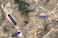
§Clark County Sandy Valley Jurisdiction- Southwest from Las Vegas
§Zoned R-U –Rural Open Land-0.5 Units per Acre
§Route 161 west from I-15
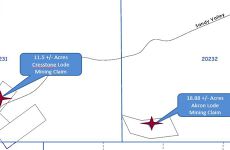
§202-32-000-002 – 18.88 +/- Acres Listed for $481,400-PS #4690 Akron Lode
§218-20-000-003 – 80.55 +/- Acres Listed for $1,260,000-Mineral Survey #4525- Sultan Lode
§222-00-001-001 – 20.21 +/- Acres Listed for $360,000-Mineral Survey #4372-Milford No.2 Lode
§222-00-001-002 – 41.26 +/- Acres Listed for $828,000-Mineral Survey #4331-Ingomar and Harriet K. Ingomar Lode
Investment highlights
Combined price $1,210,4000
Proposed site for reliever airport supplementing Harry Reid Int'l airport will be along I-15 just south of Jean and the Route 161
Listing Contacts
Listed by ERA Brokers Consolidated
Valuation Calculator
Login or Sign up to see Valuation Metrics
Sign up for Crexi to see valuation metrics for this property
Loan Amount
$0.00
Annual Debt Service
$--
$--
Annual Cash Flow
$--
$--
Valuation Metrics
0
DSCR
--
Cap Rate
--
ROI
Map
Broker Selected Comps View More Comps
Property History
Similar Properties
Is there information that looks off?