

Hobbs Island
Land | 344 acres
Marketing description
As Chattanooga, Knoxville, Decatur, and other towns along the Tennessee River are doing or have done, Huntsville, Alabama has started to develop its River front and we have something unique no one else has…A 2.5 mile long x .5 mile wide island. Counting an interior lake, the island can have +- 8 miles of waterfront. Locally known as Hobbs Island, this is the first time Hobbs Island has been listed for sale. Hobbs Island is suited for a mixed use development or destination point accessible by a new bridge or ferry. Utilities are along Hobbs Island Road, but will require boring under the river. This is a beautiful property with unlimited potential.
Investment highlights
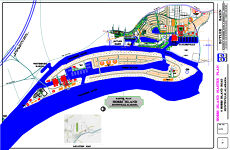
A Descriptive Trip Around Hobbs Island (This is the text for the drone video tour around Hobbs Island
As Chattanooga, Knoxville, Decatur, and other towns along the Tennessee River are doing or have done, Huntsville, Alabama has started to develop its river front starting with Butler Basin and expanding in and around the historic old town of Taylorsville. Talk is about connecting the river area to downtown Huntsville by passenger train traffic on the rail line Huntsville acquired in the 70s. As Huntsville experiences phenomenal growth, focus is turning to a diamond set in the Tennessee River, Hobbs Island, truly a 334 acre, 2.5 miles long, ½ mile wide diamond in the rough. For many years Hobbs Island was farmed using the ferry service available at that time. Today, a bridge over 200 feet of water would open up the most exclusive development opportunity imaginable.
As one crosses the Tennessee River at Whitesburg Bridge, a glance east shows the northern most tip of Hobbs Island along with Ditto landing and the old State Docks. The unique setting would make a perfect location for a hotel or any commercial destination spot as part of a planned Traditional Neighborhood Development with the proper residential and commercial mixed to provide virtually all one would need within walking distance. Perhaps also at his location an obelisk or symbol of the destination spot…a tall light house perhaps!
As one travels by boat past Ditto Landing Marina, the first trading post in the early 1800s, up grades on access and amenities are in progress. Further up river we reach the old State Docks, a great opportunity site for a public/ private partnership. As we enter the back channel of Hobbs Island, and approach Whitesburg Marina, look up and imagine a bridge overhead to the island connecting to your left, just a quarter mile away, to the proposed Southern Bypass around Huntsville. Look to your right and see one of three proposed entrances to the interior lake of the Hobbs Island development. As we pass Whitesburg Marina, renovation is also in progress alongside the new Huntsville Rowing Club. Its members are seen even in winter rowing every day in their one, two, four and eight-man sculls preparing for competition races, both regional and national.
Next up we approach the first major private development on Huntsville River Front, Butler Basin, recognize by most for the distinctive working lighthouse you pass as you enter the basin and the gated community of Great Bend at Butler Basin. Across from the basin entrance to Butler Basin, look to your right and imagine the second entrance to the interior lake of Hobbs Island and there’s more. We are only about half way up the back 2.5 mile back channel of Hobbs Island. For the next ¾ mile we are passing, to our left, the proposed resurrection of the historic Town of Taylorsville, a Traditional Neighborhood development (TND) with the option of a large marina and dry storage area where the boats travel under the building in the water before being lifted into place by hoist. Besides the marina, residential and town composed of living/ work units around the town square, a 38 acre opportunity site for a destination point over looking the main river presents itself.
As we round the southern tip completing one side of Hobbs Island, we pass an Indian burial mound…a perfect opportunity to work with one of the tribes to establish a cultural center for their heritage and a public park and destination point. As we turn the point and head down river, imagine the homes on the island overlooking the river viewing the barge and river traffic every day from their deck. As we travel down river for the next 2.5 miles, one realizes the size of Hobbs Island. The total water front property, with the interior lake is over 8 miles.
Just before reaching the northern most tip of the island, we reach the main harbor entrance where you can see commercial dock facilities capable of docking any of the river boats that cruise the Mississippi and Tennessee River. As we pass the proposed main harbor entrance to the interior lake, commercial area and focal marina from the main channel, a view of the propose master plan will show the possibilities that could present itself as one enters the protected harbor into an Atlantean setting.
Yes, a bridge over just 200 feet of water will open up the opportunity to create the most unique destination point in the south east.
Listing Contacts
Valuation Calculator
Valuation Metrics
Map
Broker Selected Comps View More Comps
Property History
Similar Properties
Is there information that looks off?